News from Bombay
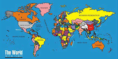
Some Bombay associates of the very cool Indo-Tibetan alliance Friends of Tibet have launched a new world map, including Tibet as it stood prior to the Chinese invasion of 1950.
If you're looking for Tibet on this new map, it is the very large white blob beneath Kazakhstan and Mongolia. Huge!
Sure, there are detractors who say "but all those areas were not traditionally governed from Lhasa;" or "in some of those areas they actually SPOKE CHINESE!" which is sort of like saying, "in some areas of New York City they speak Spanish, that means it is actually part of Mexico."
Anyway, as a big fan (almost fetishist) of maps I was glad to see it. Thanks to Rohit Singh, who conceptualized and designed the map.
Rohit Singh spoke to the gathering of both Tibetans and Indians about the significance of having Tibet in the world map. He said "A country is identified by its boundaries and presence on the political map. Tibet was an Independent country till China occupied it and diminished it from face of World Atlas. This initiative is for reestablishing Tibet on the World Map, to focus on the aspect of its position, its importance and its existence which China is out to destroy." Rohit Singh also requested the people to spread the map in order to educate the people in India about the location of Tibet in the World Atlas.


No comments:
Post a Comment